
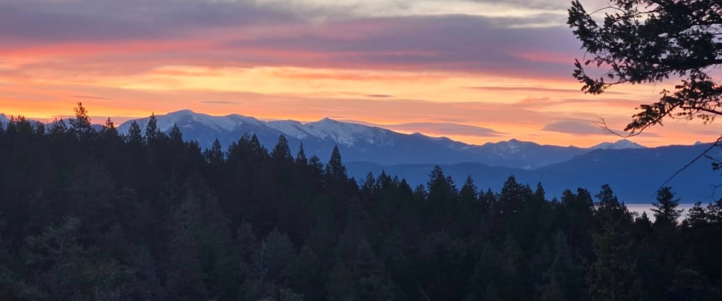
The view from the back deck of our current home, looking across our land at the Mission Mountains behind Flathead Lake.
Land Expedition – Finding Raw Property
My spouse, K, and I are originally from central Indiana, and now, about a decade later, we return to central Indiana. We currently live in northwest Montana, perched on a ridge of the southeastern Salish Mountain range overlooking Flathead Lake (yes, that image above was literally taken from my back deck).
I love it here, K not so much. She likes it warm and humid. Several years ago, we began a search for property somewhere between the mid-Atlantic seaboard and the Gulf of Mexico. We ended up finding a small piece of land in the Florida panhandle on Blackwater Bay, which has ocean access. Not sure we could have found a better name to invoke imagery of black sails, eyepatches, hooky prosthetics, and parrots quoting “Dead men tell no tales.”
But things changed, we adopted younglings, and our eldest went forth to university back in our home state. Our parents (and a single remaining grandparent between us) are aging, and we (she?) felt it necessary to return to the amber waves of grain we escaped a mere decade ago. Admittedly, we have more friends and all of our family is there, and it would be nice to have a village to lean on occasionally after 10 years of self-reliance. Though I’ve made some great friends here, circumstances have made me quite the hermit.
The Shadow of the Past
Having been down the arduous journey of finding, researching, testing, and purchasing a piece of raw land before, I knew we were in for an exhausting exercise. We probably scoured the Hoosier countryside for a year before we found the One. These were our requirements:
- No HOA or Covenants that run with the land.
- At least 3 acres, preferably 5+.
- Near enough to civilization to make grocery runs convenient.
- Locations near to my parents or K’s grandparent preferred.
- Buildable and free of risk and easements.

Our Experience Determines Our Requirements
I grew up in trailers, first near a train track and then one parked in a former gravel pit. The Little Blue River water table flooded it, and someone thought it would be a swell place to rent out lots. They weren’t wrong, it was pretty. Then I lived in barracks during my service with the Corps. K also grew up in a trailer, then a small bungalow in a small town in southern central Indiana near the White River.
Staying Away from HOAs
Then, we both lived in a townhouse apartment together with friends while we attended school. Afterwards, in a single-family ranch in the suburbs, and also part of a Homeowners’ Association. Now AGAIN in an HOA, albeit a small one of only 13 members with expansive estates. Yes, Virginia, HOAs exist even in the mother@#$%#$ frontier!
I hate them. K hates them. We all hate them. So no more HOAs! And I never want to share walls with neighbors, or even be able to really interact with them from my curtilage (something I do love about our place in Montana). Which is why I need a good buffer of acreage around the home. But K doesn’t want to feel stranded in the boonies, so we need to be close to a sizeable town with amenities. It would also be nice to be near the people we are moving back to, otherwise, we might as well just stay where we are.
Other property concerns
Finally, we need to ensure the site isn’t problematic. No flood zones. No easement required to reach it. No protected wetlands. Soils that are drainable to sustain a septic system that isn’t exotic or super noticeable. An aquifer that provides plenty of potable water. A build site that won’t require building up with engineered fill or exotic foundation structures. Oh, and it is not on the list, but it goes without saying that we need to be able to afford the property and the construction of the new home!
Taken individually, the requirements are not hard to fulfill, but as a sum, they are more akin to a unicorn.
The Land Finding Process
My process for finding real estate, raw or with a house, comes in two flavors:
- A piece of land catches my eye, then I track down and contact the owner.
- I create an endless barrage of saved searches on real estate sites, but still search manually.
Inquiring about Unlisted Land
The first is a process that has never panned out for me, but it might work for you. It’s fairly easy to do, just follow these steps:
- Identify the county the land is located in.
- Find the nearest address.
- Use the county’s GIS (Geographic Information System) service to locate the parcel and its owner’s contact info.
Using Real Estate Marketplaces
I tend to use Zillow, Realtor, and the local realtor association’s own website, which, in our most recent property search, was usually MIBOR (Metropolitan Indianapolis Board of Realtors). I find that each site might contain different information. I especially like Realtor.com’s map layers that include wildfire and flood risk. Realtor.com has a nifty feature that allows you to hide homes from returning in your search results. I usually search by acreage, hide pending (rather not get my hopes up, but if I get few worthy results, I’ll show these too), and mark HOA to be none (or fees to be $0).
My preference is to narrow my search at the beginning with a very strict set of filters. Then I draw a boundary on the map, starting with a small area, looking at all the properties available, saving them, then moving the search area. This is especially useful if you do not have to be in a specific location because of a job. I work as a software engineer and am 100% telecommute, so as long as I have internet strong enough for an audio meeting on Zoom, I’m golden.
When I looked for oceanfront property, I would just scour the eastern seaboard on the map. It was a tedious process. If I’m dissatisfied with the results, I loosen the filters. So I go from 20 acres, to 10, to 5, to 3. I would expand the property type from land to farm to single and multi-family dwellings. There might a gem with an old building that you can just bulldoze (or maybe you just find the perfect house).
How to Research Property Pitfalls
You may have totally different requirements, but here is a non-exhaustive list of things that I use to rule out properties:
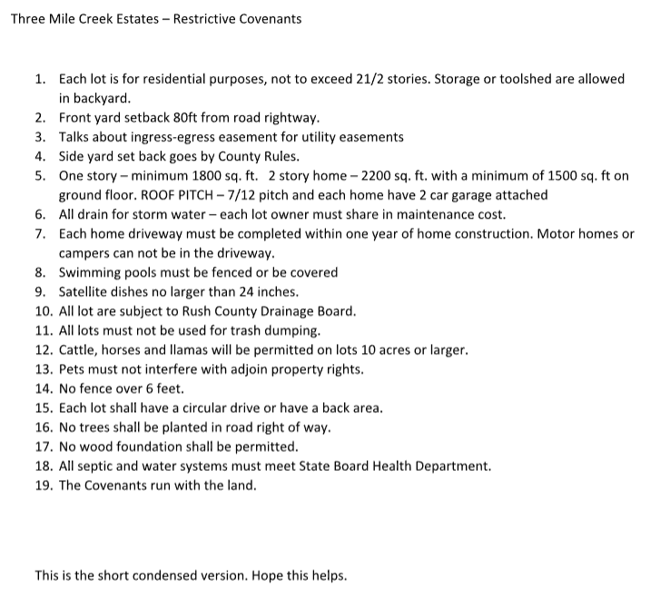
- HOAs, covenants & restrictions that run with the land (i.e. an HOA in disguise).
- An HOA is a homeowners’ association, a nonprofit (or should be) that falls under IRS Section 501(c)(4). I find it’s only a tool for nosey busybodies who like to limit freedom. An odd observation of mine is that the people who like them most also claim to like less government. This tells me they like telling other people what to do, but don’t want to be told themselves. These organizations are governed by Bylaws, which dictate how they operate (e.g., elections & fiduciary concerns) and CC&Rs (Covenants, Conditions, and Restrictions) which are often vague rules unevenly enforced across the membership that restrict what you can do with your property.
- Sometimes you can find property with deeded restrictions, also known as covenants that run with the land. These are often hidden or foisted upon the seller during closing when a property is subdivided.
- Zoning Restrictions.
- Make sure the property is zoned appropriately. Be sure to read all the zoning regulations for the county or municipality before purchasing land. This is similar to HOAs, but it’s the government. You might end up with property you cannot build exactly what you want or at all.
- Great Schools rated properties in a school district less than 6 stars.
- Even if you don’t have kids, you may not want to live in an area populated by the lowest common denominator of human intelligence. If the schools suck, their failures aren’t moving away, they are living next to you.
- Flood zones.
- Self-explanatory. You don’t want to be paying more in flood insurance than your mortgage. FEMA is a good resource if you want to learn more about flood and storm surge zones.
- Landlocked with no deeded easement (and I tend to shy away from easement-only access).
- An easement is either someone else’s right to use your property, often as egress, or you need rights through someone else’s property to access yours. Sometimes there is no easement established, and the land is locked. No one has to grant you rights of access, and you will likely have to pay a fortune to obtain them if some genius subdivided the property without first establishing an easement. Easements are no fun either way. Everyone involved in their use has a burden to maintain it and if you share an easement with multiple owners, disputes about road maintenance can be difficult.
- Water (and mineral) rights.
- This is more of an issue in the American West, but you need to ensure you have rights to the water on and under your property. Also, be sure to understand if some old mining company has mineral rights, because that means they can mine under you and create such wonderful geology features as sinkholes.
- Near nuisance properties.
- This is all about smells, noises, pests, and traffic (factories, agriculture elevators, pig farms, airports, stagnant water, high school parking lots).
- Odd-shaped property.
- Be aware of long, narrow properties or properties that look like a child drew the boundary. It’s a tell-tale sign for undesirable property features and someone else already took the good parts. Or you are on the coast and people are trying to squeeze all the money they can and leave you with a plot you can build a 15-foot-wide home on, after setbacks.
- Protected areas (wildlife or forest).
- You may or may not want this. But if the potential property has it, be sure to understand what is not protected, if anything, has buildable sites. These protections often reduce property tax, so they can be beneficial, or they can be a pain in the ass to work around.
- Fully wooded property.
- This is another item that could be beneficial or not. Clearing trees may require you to install exotic/costly above-ground septic systems due to disturbed soil and poor drainage left behind.
Beware of Hidden Costs
Not so much pitfalls, but something that can blindside the unaware. Make sure you do your due diligence for the following items:
- Utility access.
- Electricity: so you bought 100 acres and plan to set your home as far back as possible. If you are not planning to be off-grid, the cost of getting power from the nearest line and running it to the meter attached to your structure might cost more than a house.
- Sewage/Water: be sure to understand if you must connect to a utility for sewage and water. Do you have to install a septic system? A well? How is the drainage of the soils? Is there water contamination from farming? See if you can run a water test on your future neighbor’s water. How deep does the well need to be and does it go through rock, making it more expensive? How many gallons per minute can your aquifer sustain? No one likes water with low pressure.
- Permits and fees.
- Are there greater financial burdens than normal with permits and fees? You will need to call your local planning authority to find out.
- Driveway access.
- If the property is unimproved, you will need to install a driveway. You need to contact the local highway department to understand their requirements, and also know that building a driveway that will withstand construction equipment is not cheap. Much like electricity, the further away you are from the county road, the more it costs.
- Clearing land.
- Will the property require extensive clearing of debris? Is there a lot of junk being left behind? This all costs time and/or money.
Collect the Listings in a Google Sheet
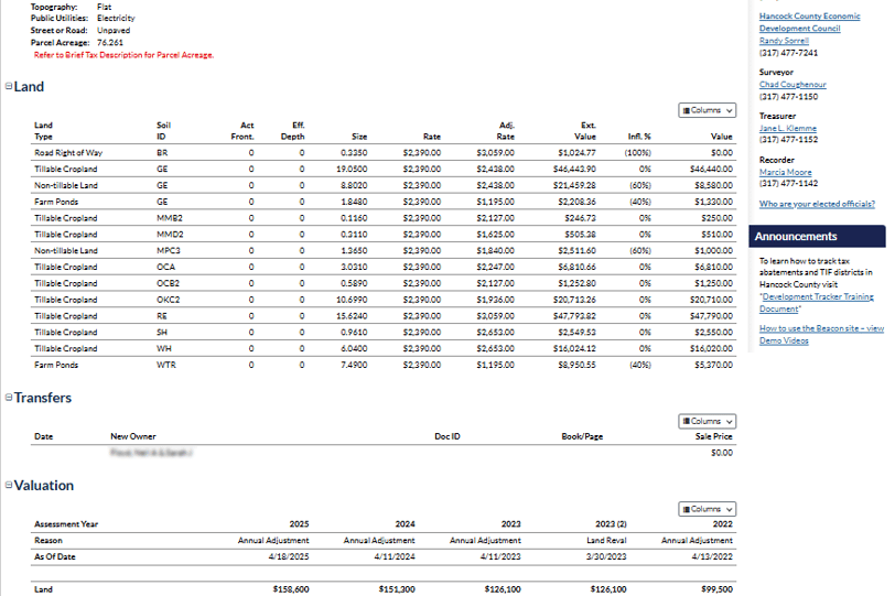
I take my saves, I add them to the spreadsheet (specifically Google Sheets, so I can collaborate with K easily), then I systematically use the GIS service the county contracts with to research potential pitfalls of each one. For our county, they use Beacon. Below is an example parcel of property and it has some very useful information. The layers on the left navigation menu give you access to important information, like floodplains. Note a lot of this property is unusable for home sites because it sits in the AE floodplain, which is the highest risk flood zone outside of coastal regions (read this article for more information about flood zones).
I add columns like acreage, taxes, distance to nearest town, the school district’s score from Great Schools, how its district voted in the last election, checkboxes for features (waterfront, ocean access, mountain view, wooded, pond, the price and price per acre, days listed – if this number is high, it is a great indicator that something is wrong), the address or a map pin, a link to the listing, and two columns for ranking (one for K and one for me). This allows us to look at a glance at the vital statistics and compare them.
The owner address can be found in the lower right-hand corner. I’ve blurred it as a courtesy, but it’s all public information. The layers can also show you rights of way (easements), wells, septic systems, zoning (more on this later), school district, contour lines for elevations, regulated drainage, election districts, soils (important for a rough idea of whether select fill will be required), and aerial views from various years so you can see development trends. The caveat here is that each GIS is different, and even within the same GIS, each county may provide more or less information. In Hancock County, Indiana, if you click on the parcel, you can see a parcel report with tax history and sale prices.
Zoning Ordinances
Now that you have the details, you need to look up the county zoning ordinances for your property. You may find the township or specific zoning places restrictions on what you can do with the property. For my county, the ordinances can be found at https://www.hancockin.gov/247/Planning-Building
If we find Zone Agricultural (A), we will find a bunch of rules specific for my zoning. Specific to Zone A are the following:
- Minimum lot area: 43,000 square feet.
- Maximum lot area: not applicable.
- Minimum lot width (measured at front setback/build-to line): 125 feet.
- Maximum lot coverage (including all hard surfaces): 25%.
- Minimum front yard setback – (measured from street right-of-way): 50 ft.
- Minimum side yard setback – (measured from property line): 15 ft.
- Minimum rear yard setback – (measured from rear property line): 15 ft.
- Minimum living area per dwelling: 1,200 square feet.
- Minimum ground floor living area: 1,200 square feet.
- Maximum primary structures per lot: 1 dwelling.
- Maximum height: 40 feet.
Note, these are not all the rules and restrictions; careful reading needs to be done beyond your zoning. For instance, I cannot build an accessory building for any purpose other than agricultural before a primary dwelling unit exists, at least not without a special exception, which requires meetings and notifications to neighbors. See §156.062.B.1.a.
Final Steps
The very next step is to put boots on the ground. You will want to see and walk the property firsthand. This might require permission via a real estate agent first, but if its just an empty field, go walk it. Take a gander at the neighboring properties. Drive around the area if you are unfamiliar with it.
Perhaps before any of this, I should have told you to find a reputable real estate agent. We’ve had nightmare scenarios with horrible but highly recommended agents. Luckily, we developed a friendship with one we trust a long time ago, and she was able to help us out. Over the course of a year found a few properties and she spearheaded our negotiations for us.
All but one were quickly eliminated. Once a property is chosen, the next step is to hire a geotechnical engineer to do a soil test for septic systems and possibly ensure the soil stability for one or more potential build sites. Then, of course, title and easement searches that your real estate agent will hopefully line up for you.
Before closing, be sure to do the following sanity tests on the prospective land:
- Soil tests.
- You will need a geotechnical engineer to test the drainage. Walk the property and mark at least two build sites and two septic sites. Look for where the land naturally falls, if possible, for a possible septic install. Many counties are trying to protect their drinking water by making the design requirements more stringent, using dosing tanks, and their fields can be tall and stick out, but if you work it into where your property falls, it can be better hidden.
- Opting to test the stability of the soils will determine the size of your footings. See Section R403 of building code for more information.
- Title & Easement search.
- Be sure to know of any leans, easements, or restrictions on your land.
- Survey.
- Get a new survey that marks the boundaries of the property. Do not trust existing markers or the word of sellers, neighbors, or the real estate agent. Get a survey and know.
Did We Meet Our Requirements?
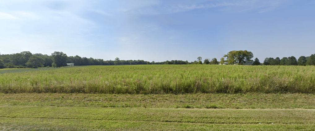
The above photo is from the paved county road (I note it’s paved, because we have 2 miles of dirt, not gravel, county road before we hit our paved driveway in Montana) in front of the 10 acres we acquired. I’ll revist the list of requirements and note whether we met them or not:
- ✅ No HOA or Covenants that run with the land [Absolutely zero restrictions beyond county zoning, which is Agricultural, the least restrictive zone].
- ✅ At least 3 acres, preferably 5+ [Got a whopping 10 acres].
- ✅ Near enough to civilization to make grocery runs convenient [Less than 18 minutes to shopping/restaurants].
- ✅ Locations near to my parents or K’s grandparent preferred [10 minutes and 90 minutes, respectively].
- ✅ Buildable and free of risk and easements.
- ✅/❌The Great Schools ratings were mixed, the elementary (the one most important the moment was 7/10, the highschool is 3/10.